Sunny Bay to the Buddha
This spectacular bike ride over Hong Kong's largest island involves beautiful views and runs alongside pristine natural beaches, but the hills are very steep and should not be attempted in high temperatures or strong rain. This is the hardest route on the site, so bring plenty of water and a towel to cool off in the sea!
The basics
|
Rating: A1
Distance: 60km approx. Starts: Sunny Bay MTR Exit A Ends: Tung Chung MTR Exit B, or return same route to Sunny Bay Urban/rural/mixed: 5/85/10% Surface: Excellent throughout, though note there is some buckling of the surface on South Lantau Road (between the bottom of Tung Chung Road and Tong Fuk) Difficulty of navigation: Very easy, although finding the Tung Chung Road leaving Tung Chung can add a few minutes. |
For more photos, see Tung Chung to Mui Wo, which covers much the same route. The photo at the top of the page is taken from South Lantau Road.
|
Maps and elevation
The details
This is a great ride for those who like hills. From Sunny Bay Exit A, you need to take the counter-intuitive way which is to head away from Tung Chung, i.e. to the east, in order to cross the MTR tracks and highway. You then take the first obvious right turn and DO NOT continue towards Disneyland.
The road continues, mostly straight with some mild undulation, all the way to Tung Chung. Keep going and at the end, turn left and follow this road to Tung Chung MTR. From Exit A cross the road to the bike park. Follow the pedestrian path for a hundred metres or so before picking up the cycle path, which then takes you out to Tung Chung Road. Note that there are several short additions to the path - try to keep alongside the main road.
The climb up to Pak Kung Au is a total of around 340 metres. This is a very steep climb and the route is frequently used by buses and heavy goods vehicles. Fortunately there is a well maintained pavement that can be used if you feel unsafe. The views from the upper end of the climb are spectacular, framing the airport beautifully. Note there isn't much shade on the climb, so avoid doing this ride in hot weather. Take note of any problems with surfaces, since you'll descend this way at the end of the ride.
From the top, there is a long and beautiful downhill. Again, this is very steep - so avoid in rainy weather and check your brakes before starting.
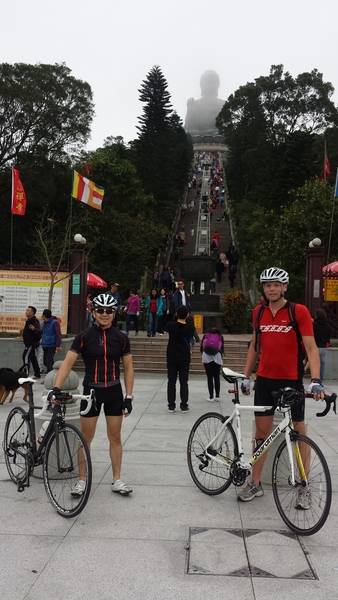
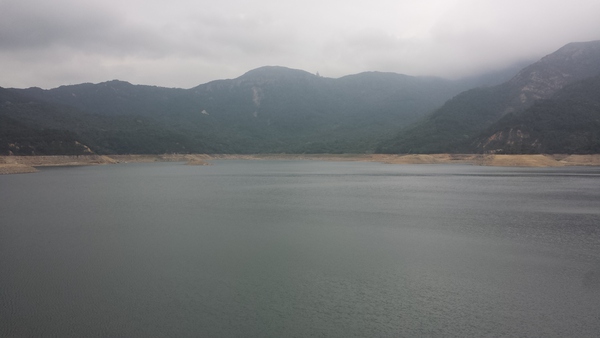
At the roundabout turn right, and follow South Lantau Road all the way to the reservioir. Cross the dam via the same road, and then begin the second major climb. This is a bus route and becomes narrow at times, so cycle defensively (don't let buses past you unless you have room to 'escape' off the road if another bus comes in the opposite directly). The road eventually reaches Tai O, but this ride turns right at the top, signed for the Nong Ping Buddha. This is a steady climb with some steep bits at the start and end, but a middle part which is quite pleasant. At the top, keep following the road ahead until you eventually see the arch and beyond that the flags which are at the bottom of the stairs to the Buddha. There are plenty of places to eat and drink here.
The route then returns the same way. Head downhill, picking up South Lantau Road. When back at the roundabout, you can choose to go straight on ('right') following directions for Mui Wo. There are two strenuous climbs on this route, and while they are relatively low (no more than 100m each) they are tough in hot weather. The route here is very shaded. Further details of this route are below.
Alternatively, if you want to return to the MTR and don't mind another climb, then turn left at the roundabout and go back the way you came. Though the map finishes at Tung Chung, you can always return the same way all the way to Sunny Bay.
Further details if you're returning to Mui Wo:
On arrival at the roundabout, go straight on to follow the road to the ferry terminal. If you have time to spare before the ferry back, there are several bars overlooking the car park. Or, get a beer from the 7-11 and sit with a view of the sea!
For early finishers, turn left at the roundabout and pick up the cycle path down to Silvermine Bay with its pristine beach (with shark nets).
The road continues, mostly straight with some mild undulation, all the way to Tung Chung. Keep going and at the end, turn left and follow this road to Tung Chung MTR. From Exit A cross the road to the bike park. Follow the pedestrian path for a hundred metres or so before picking up the cycle path, which then takes you out to Tung Chung Road. Note that there are several short additions to the path - try to keep alongside the main road.
The climb up to Pak Kung Au is a total of around 340 metres. This is a very steep climb and the route is frequently used by buses and heavy goods vehicles. Fortunately there is a well maintained pavement that can be used if you feel unsafe. The views from the upper end of the climb are spectacular, framing the airport beautifully. Note there isn't much shade on the climb, so avoid doing this ride in hot weather. Take note of any problems with surfaces, since you'll descend this way at the end of the ride.
From the top, there is a long and beautiful downhill. Again, this is very steep - so avoid in rainy weather and check your brakes before starting.
At the roundabout turn right, and follow South Lantau Road all the way to the reservioir. Cross the dam via the same road, and then begin the second major climb. This is a bus route and becomes narrow at times, so cycle defensively (don't let buses past you unless you have room to 'escape' off the road if another bus comes in the opposite directly). The road eventually reaches Tai O, but this ride turns right at the top, signed for the Nong Ping Buddha. This is a steady climb with some steep bits at the start and end, but a middle part which is quite pleasant. At the top, keep following the road ahead until you eventually see the arch and beyond that the flags which are at the bottom of the stairs to the Buddha. There are plenty of places to eat and drink here.
The route then returns the same way. Head downhill, picking up South Lantau Road. When back at the roundabout, you can choose to go straight on ('right') following directions for Mui Wo. There are two strenuous climbs on this route, and while they are relatively low (no more than 100m each) they are tough in hot weather. The route here is very shaded. Further details of this route are below.
Alternatively, if you want to return to the MTR and don't mind another climb, then turn left at the roundabout and go back the way you came. Though the map finishes at Tung Chung, you can always return the same way all the way to Sunny Bay.
Further details if you're returning to Mui Wo:
On arrival at the roundabout, go straight on to follow the road to the ferry terminal. If you have time to spare before the ferry back, there are several bars overlooking the car park. Or, get a beer from the 7-11 and sit with a view of the sea!
For early finishers, turn left at the roundabout and pick up the cycle path down to Silvermine Bay with its pristine beach (with shark nets).